Wishful thinking...
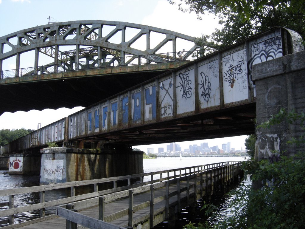 As I was strolling along Boston's Charles River Esplanade this past Saturday (and it so happened that I was chatting on the phone with Ben, the administrator for this blog), I happened upon a rather prominent, yet under appreciated, landmark across the Charles River. Above is pictured the BU Bridge, which crosses over a diagonally situated railroad crossing, which in turn crosses the Charles River at a point where it narrows as it travels westward towards the suburbs. I've always been intrigued by the history of these crossings, particularly the railroad one, since I have never seen a train on the trestle. It's also the only place in Boston where a plane can travel over a car over a train over a boat (I blogged about this once a long time ago).
 (Below)...a view from beneath the railroad bridge, with wooden railroad ties visible to the right. While apparently built wide enough to carry two parallel rails, only one rail currently crosses the steel girder.
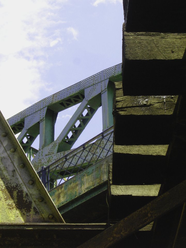 The road bridge, which replaced an earlier wooden structure, was built in 1928 as the Cottage Farm Bridge and was renamed in the late 1940s in honor of Boston University. It carries Route 2 from Cambridge on its north bank to the Boston University area to the south. Although I haven't been able to dig into the history of the railroad bridge, I was able to find out that it carries the Grand Junction Line, a little-used railroad connector that bridges the Worcester Railroad line of the southwest to the heavily-trafficked commuter rail lines northeast of Boston. This line forms a rough border between the Massachusetts Institute of Technology and the rest of Cambridge city to the north.
So far, this information wasn't too interesting. However, I soon found that the railroad trestle serves as the only remaining usable link between the railroads north of Boston with the famously busy Amtrak Northeast Corridor, which carries MBTA commuter rail trains and electrified Amtrak Acela Express and Regional services from Boston to urban centers to the south. While the railroad bridge continues to decay across the Charles River, it is still used on occasion by the MBTA Commuter Rail system (MBCR) to transfer equipment between its southern and northern train yards, since there exists no other link between the Northeast Corridor's northern terminus at Boston South Station and the southern terminus of the upper New England rail lines at North Station. This has proven an inconvenience for many rail passengers needing to switch trains from the southern Regional, Acela, or Lake Shore Limited routes at South Station to the North Station's Amtrak Downeaster, serving points northward and terminating at Portland, ME. While such a connection is possible by using the downtown MBTA subway, many Amtrak employees or station agents simply suggest customers to take a cab between stations.
Thus began Boston's ambitious planning to build a North-South Rail Link, which involved building a 1-mile long rail connector through underground tunnels to connect North Station with South Station. The northern portal to the tunnel system would be constructed just north of the Charles River, and the southern end of the facility would exit the ground at two port
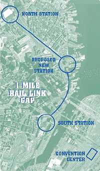 als, one serving rail lines continuing due south through South Bay and the other portal serving rail lines to the southwest near the current Back Bay Station, which is currently the second to last stop for Amtrak and commuter rail trains before they end their journeys at South Station. A new "central" station, near the current MBTA Blue Line Aquarium station, would be built midway through the link to connect rail services with central points of the downtown subway.
While planning for the link continued to advance to the point that engineers were planning access points for stations and how to reroute existing underground traffic, made more complicated by the recent completion of the underground I-93 Central Artery tunnel system, the plan was abandoned earlier this year due to exorbitant costs necessitated by the intricate planning needed for such a system. However, when the I-93 Central Artery (AKA "Big Dig") was being constructed, one portion was built on top of underground concrete walls placed for the purpose of housing a portion of the future link, in case such plans for a North-South Rail Link would materialize.
So, for now, the lonely railroad trestle, while continuing to decay and serving as a billboard for local college graffiti artists, still serves a vital purpose for Boston's railroad system as a current north-south link. Perhaps it's for the better, as the current situation allows the MBTA to boast it's state-of-the-art and clean subway system to traveling tourists, who I'm sure are eager to get off a train after a 17-hour ride from Chicago, board a red line train at South Station (after fighting through crowds and contending with the complicated Charlie Card machines), transfer at Park Street (the MBTA's busiest and most hectic station) to a Green Line Trolley, and exit at North Station (in the process getting lost and having to cross Causeway Street 3 times before finding the entrance to North Station, which happens to be the main entrance to Boston's mammoth sports arena, TD Banknorth Garden!) to board the 2-hour train to Portland. Now those are fun times!
(Below)...it would have been too pretty for Boston, anyway...and since when does Boston have room underground for this?
 A note about sources...while I link heavily to Wikipedia, which many may claim to contain dubious information since it's relies on contributions from the general public, I have found that, in most cases, information regarding railroad and aviation history can be confirmed by other sources. If you find any information to be incorrect on this blog, comments are certainly appreciated.
Please stay tuned for a post concerning my travel yesterday along the Northeast Corridor between Boston and Providence, RI...coming shortly.
posted by Evan at 6:07 PM
![]()


2 Comments:
Fantastic post. I've wondered why there's no straight connection between the north and south stations. I'm not sure about the popularity of the Downeaster, but given the number of trains operated daily between Boston and Portland, I suspect it boasts a loyal ridership. Too bad the plan was abandoned; but no doubt it was exorbitant--extravagant, even.
Actually, the Downeaster has been enjoying renewed interest over the past few months...ridership was up 31% as of the end of July.
Post a Comment
<< Home